How Multiconsult streamlined offshore interpretation with Ground Model for ArcGIS
From energy to infrastructure, offshore projects rely on accurate subsurface interpretation. But combining diverse datasets into one clear picture is no simple task.
How Multiconsult streamlined offshore interpretation with Ground Model for ArcGIS
From energy to infrastructure, offshore projects rely on accurate subsurface interpretation. But combining diverse datasets into one clear picture is no simple task.
When working with offshore energy and electrification projects, Multiconsult’s geotechnical engineers faced a growing challenge: how to effectively bring together complex data from seismic surveys, CPTU soundings, and soil samples – and turn it into meaningful interpretations, while keeping track of changes and communicating insights clearly across the team.
We needed a tool that could streamline the interpretation process and allow us to work more efficiently with large datasets.
As one of Norway’s leading engineering consulting firms, Multiconsult works across sectors such as building and real estate, mobility and transportation, energy, environment, and geotechnics. For their offshore projects, much of the analysis and interpretation is done using GIS tools, making it a clear advantage to choose a solution integrated with ArcGIS Pro.
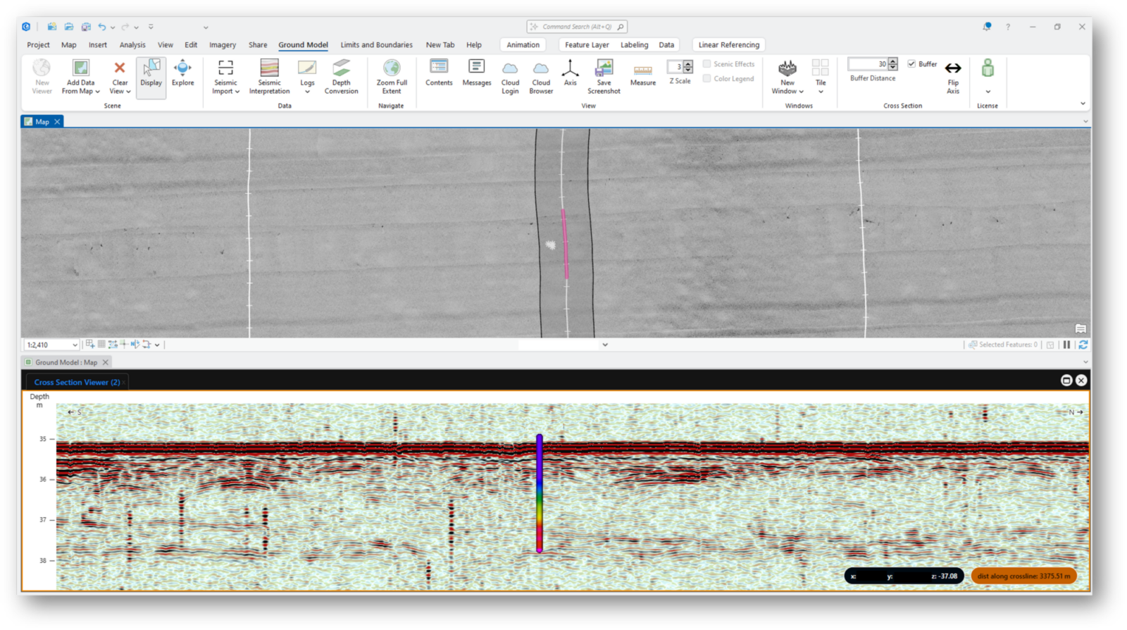
Integrated map and seismic cross section in ArcGIS Pro. Source: Geocap illustration
From fragmented workflows to seamless interpretation
By adopting Ground Model for ArcGIS Pro from Geocap, Multiconsult’s geotechnical team gained a powerful, GIS-native tool for mapping seabed conditions and interpreting potential submarine landslide activity. Instead of relying on separate platforms, they can now bring seismic profiles, CPTU data, and soil samples together in one environment, improving collaboration, reducing error, and accelerating insight.
The solution integrates seamlessly with Multiconsult’s CloudGIS platform, enabling a flexible, cloud-based workflow where data and interpretations stay synchronized across teams and locations. Ground Model for ArcGIS Pro also handles large datasets smoothly, supporting high-volume offshore projects without compromising performance.
A key strength of the collaboration with Geocap has been the ability to adapt the tool to Multiconsult’s specific needs. For example, interpretation tools were refined to allow users to mark and characterize submarine landslide events directly in cross sections. This includes the ability to define geometry, assign interpretation rationale, and update dynamically throughout a project.
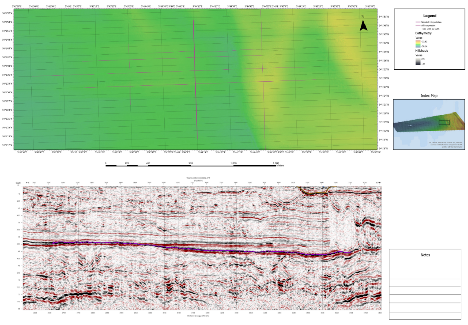
Map Series with Seismic Cross Section in ArcGIS Pro. Source: Geocap illustration
Standardized reporting with Map Series
Multiconsult has adopted Geocap’s functionality for creating seismic section figures with interpretations. Seamlessly integrated with ArcGIS Pro’s Map Series, the solution enables the team to generate standardized, high-quality figures that combine maps and cross sections directly within ArcGIS Pro. This has greatly improved the consistency and efficiency of their reporting deliverables.
Ground Model for ArcGIS Pro is a tool in constant development that has helped us transform established workflows into something faster, more structured, and more professional. That`s something our clients appreciate.
Real results, and an eye on the future
Since adopting Ground Model for ArcGIS Pro, Multiconsult has transformed how they work with offshore subsurface data. Their engineers, with experience in seismic interpretation and GIS, now interpret and document data faster, with greater clarity and confidence across the team. The result? A faster, more coordinated workflow, and clear, professional deliverables delivered right from ArcGIS Pro.
Contact us